Keep the mainland and island visits distinct
The national park's full name can make a simple visit sound more complicated than it is. Khao Laem Ya and Ko Samet belong to the same wider protected area, but they require different journeys. The headland is on the mainland near the park headquarters; Ko Samet is an island reached through a separately arranged crossing.
For this outing, give your driver the mainland Khao Laem Ya entrance or park headquarters on the Mae Ramphueng–Phe coastal road. A boat pier in Ban Phe is not the starting point for the headland walk. Establishing that distinction prevents a road-based afternoon from becoming an unintended island itinerary.
The protected area includes coastal land, sea and several islands. TAT's park account records its establishment in 1981. You can appreciate that wider setting from the headland without needing to visit every part of it in one day.
Choose the mainland for rocky shore views, short coastal movement and the contrast between grassy slopes and sea. It works particularly well as a focused outing from a Rayong coastal base, with a meal or beach stay elsewhere before or afterwards.
Choose the walkway or the nature-trail circuit
There are two useful levels of commitment. A shorter visit uses the developed coastal approach and selected viewpoints. A longer walk includes the nature-trail circuit, with uneven ground and changes in level. They should not be described as the same easy stroll.
TAT's April 2026 account describes a coastal route of about five hundred metres, starting near the pavilion by the park café. It combines raised wooden sections with glass sections and a projecting sea-view area. Check which parts are currently open and how the route returns before starting.
DASTA describes a nature-study circuit of roughly 1.4 kilometres, linking shoreline and hill sections. Its account allows for different directions around the loop, with coastal rocks and vegetation among the subjects for observation. A loop distance does not remove the physical demands of its surface or exposure.
Choose the shorter route if you mainly want the coastal setting and a few good views. Choose the circuit if everyone wants a proper walk and is comfortable with the conditions. A group can have a rewarding visit without completing the longest available path.
Start with the white waterfront structure
The small white structure near the park's waterfront is one of Khao Laem Ya's recognisable features. It is often photographed against the open sea. TAT describes it as a small raised wooden, house-like structure near the pier, rather than identifying it as an operational navigation lighthouse.
Look at it from the authorised public area and follow any access instructions. A queue for a photograph should not block the path or encourage people to climb beyond permitted surfaces. The surrounding view remains available even if you decide against taking the familiar posed picture.
Use this first stop to orient yourself. Identify the developed waterfront, the route continuing beside the coast and the headland beyond. Knowing how those elements relate makes the decision about a longer walk easier than simply following the next group along a path.
Allow around fifteen to twenty minutes for arrival and this first view, extending it if you enjoy watching the water. It is a suggested allowance, not a timed attraction. A crowded weekend can change how long the photographic stop takes without changing the distance to the next part of the route.
Walk the coast at observation pace
The developed coastal route brings you close to the headland's rocky edge while providing a defined visitor path. TAT's current account describes alternating wooden and glass sections, with places to look out over the sea. The changing surface is one reason to pay attention to the path rather than walking continuously through a phone screen.
Stop where there is room to let others pass. Compare the sheltered and more exposed parts of the shore, the shape of the rocks and the way waves break around them. A short route offers enough variety when you take time to observe rather than treating the next viewpoint as the only destination.
The existence of a path beside the rocks does not make the rocks an alternative route. Stay within the permitted walkway and signed areas, particularly where spray or wet surfaces change the conditions. A photograph from farther out is not a reason to leave the route.
Check the return before committing to the outward section. Some visitors will be content to use the coastal route and retrace the permitted way. Others may continue into the longer nature route. Make that choice while everyone still has the time and energy to finish comfortably.
The grassy headland offers a different view
Khao Laem Ya is a low headland, with grass and low shrubs on the more open slopes. Rayong's provincial administration highlights the effect of coastal wind on this exposed setting. The contrast with the rocky shoreline gives the walk its distinctive character.
The higher or more open route is not simply a continuation of a flat promenade. TAT's attraction account warns of sloping and uneven ground on the hill approach. Wear footwear that suits that surface and choose the route according to the least confident walker in the group.
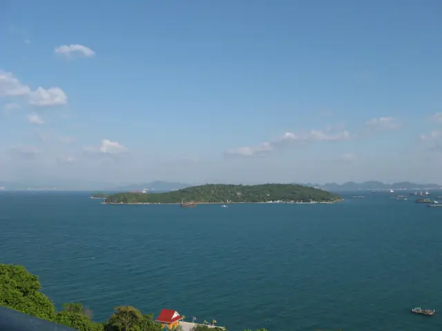
From suitable viewpoints, the wider landscape includes Mae Ramphueng Beach and Ko Samet. TAT identifies the island's western side, towards Ao Phrao, in the view from the headland area. Use those landmarks to understand the geography, rather than assuming that every island visible from Rayong is Ko Samet.
A clear view depends on the weather. Coastal cloud, haze and wind can alter the experience, and an attractive sea colour in a photograph does not establish the conditions for your date. The form of the headland and the movement of the water can still be interesting when the far horizon is less distinct.
Give the nature circuit its own time
If you choose the approximately 1.4-kilometre circuit, allow at least an hour for a relaxed walk and more for pauses, heat or a slower group. That is an editorial planning allowance. Distance alone is a poor guide to how long an uneven nature route will take.
DASTA describes both coastal and inland portions, with interpretation at points along the way. Use the signs to connect plants and landscape to the setting. The point of a nature trail is not only reaching the final sea view; the transitions between open headland and more sheltered vegetation are part of its subject.
Do not turn a late arrival into a rushed loop. If the available daylight or closing arrangements leave little margin, choose a shorter section or the developed coastal visit. Completing the circuit should be a positive choice made at the start, not a consequence of assuming that any path will quickly lead back to the car.
If staff have closed a section, use the current alternative they indicate. Older visitor reports and photographs can remain online after access changes. The signed route and current park instructions are the relevant guide on the ground.
A practical two-hour visit
Use the first twenty minutes for entry, parking or drop-off, and orientation at the waterfront. Establish the currently open route and the place where your vehicle will meet you afterwards. A park entrance and the final walking arrival area may be different stopping points.
Give the next hour to either the selected coastal route or the main nature circuit. On a first visit with mixed walking abilities, the shorter route and several pauses may be the better use of time. A group choosing the circuit should avoid adding repeated detours at its beginning.
Keep the final part of the visit for a rest, one last permitted view and returning to the collection point. Add a third hour if you want a slower nature walk or to remain for late-afternoon light. A ninety-minute visit is possible when you deliberately limit the route to the waterfront and shorter coastal sections.
These timings describe possible independent visits, not a park-operated schedule. A longer walk, a café stop and a wait for sunset all require time. Decide which of those is important instead of expecting them to fit automatically into the shortest allowance.
Late afternoon and sunset need a return plan
Khao Laem Ya is promoted as a sunset viewpoint. The changing light can give the sea and grass a different character, making a later visit appealing. It also creates a practical boundary: the walk back still has to fit the current park arrangements and remaining visibility.
Choose a viewpoint that suits the route you can complete. Do not begin an unfamiliar uneven loop merely because the light is becoming attractive. Someone who wants to watch the last part of the afternoon may prefer a developed coastal stop with a clear return.
Arrange the vehicle pickup around the actual visit rather than a generic sunset time copied from an old itinerary. A cloudy evening can make it sensible to finish earlier, while a clear one may invite a longer pause. Tell the driver how the collection arrangement will work if your timing changes.
A sunset view is a possible feature, not a promised performance. The headland remains a worthwhile coastal visit when the sky does not produce dramatic colours. Plan a route that would interest you in ordinary daylight as well.
Camping is a separate overnight decision
The headquarters area has camping facilities, but a camping stay requires a separate plan from a day visit. TAT's April 2026 information describes a limited waterfront camping area and directs visitors to the visitor centre for arrangements. It also reported park houses undergoing renovation at that time.
Confirm current overnight access, capacity and facilities directly before relying on a place to stay. Do not interpret an older bungalow or tent listing as evidence that accommodation is available on your date. An evening visit followed by a prebooked hotel elsewhere is a different, simpler arrangement.
If you do camp, settle the practical details before beginning a long walk: authorised pitch, equipment, washing facilities and the rules for the overnight area. The availability of camping does not extend every walking route into an unrestricted nighttime activity.
For many first-time visitors, a focused afternoon from nearby accommodation is enough. Choose an overnight because you want the camping experience itself, rather than because a late photograph has left the road journey unplanned.
Arrive by the correct coastal road
The mainland park headquarters lies on the coastal road between the Mae Ramphueng area and Ban Phe. A direct road transfer is the clear option from either area or from a Rayong hotel. Give the driver the mainland entrance and confirm the permitted drop-off or parking point.
If using local transport for part of the journey, establish the final connection and return before departing. Reaching Ban Phe or a main road does not necessarily provide a convenient walk to the headland. A boat-oriented transport service may also be heading to an island pier rather than your intended park entrance.
The 2026 TAT account states that attractions around the mainland headquarters are open for visits throughout the year. That does not guarantee every path after storms or maintenance, and it should not be applied to all islands within the national park. Check the particular mainland route and the day's operating arrangements.
Choose Khao Laem Ya for a compact encounter with a varied coast: the developed waterfront, rock and water, and an open grassy headland. A clearly selected route lets you enjoy those differences while keeping the effort and return journey realistic.
Sources and related planning
- TAT: April 2026 mainland visitor account, walkway and facilities
- TAT: national park attraction and route differences
- DASTA: Khao Laem Ya nature-study circuit
- Rayong Provincial Administrative Organisation: headland setting
- Thailand Tourism Directory: Khao Laem Ya mainland attraction
- TAT Newsroom: park history and development of the coastal trail
- DNP: Khao Laem Ya–Mu Ko Samet National Park
- Thailand destination planning